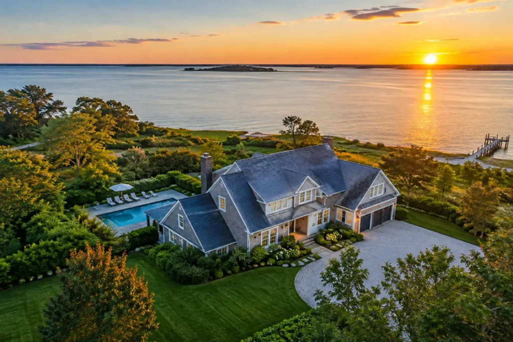
A buyer can forgive a dated backsplash. They are far less likely to forgive discovering that the “waterfront” home backs up to a busy road, sits far from the beach, or has no usable outdoor space. Aerial listing photography solves that problem before the first showing by putting the property in context. For South Florida agents, that context is often the reason a buyer clicks, saves, shares, and schedules a tour.
Aerials are not simply dramatic overhead shots added to a photo package. Used strategically, they answer the questions buyers ask when they are evaluating location, privacy, views, lot size, access, and lifestyle. They help serious prospects understand what makes a property worth seeing in person.
Why Aerial Listing Photography Earns Attention
Most listing photography focuses on the home itself: the kitchen, primary suite, pool, living areas, and finishes. Those images matter, but they cannot show how a home relates to its neighborhood. A drone can reveal the relationship between the pool and the water, the size of a corner lot, the distance to a marina, or the walkability of a downtown location.
That distinction is especially valuable across Miami-Dade, Broward, and Palm Beach. A home’s position may be its biggest selling point. Buyers want to see whether a canal provides direct ocean access, how wide the waterway is, whether a building has clear skyline views, or how close a property sits to golf, parks, schools, and major roads.
The best aerial images make these advantages immediately understandable. Rather than asking buyers to interpret a map or imagine the setting from a ground-level photo, they let the listing show it. That clarity can reduce unnecessary showings while giving qualified buyers a stronger reason to act.
What Buyers Should See From the Air
Effective aerial coverage is planned around the property, not captured as a generic collection of high-altitude drone photos. A luxury waterfront estate needs a different visual story than a townhome near Las Olas or a family home in a gated community.
For most listings, the strongest drone image set shows four things: the full property footprint, the immediate surroundings, the lifestyle features nearby, and the view or access that creates value. This may include the backyard layout, dock and seawall, beach proximity, nearby green space, golf course frontage, private road access, or the home’s place within a highly recognizable neighborhood.
A straight-down image can be useful for showing lot shape and outdoor amenities. A lower, angled image usually feels more cinematic and helps buyers understand depth, privacy, and views. Wider neighborhood images work best when they communicate a specific benefit, such as proximity to Biscayne Bay, an intracoastal waterway, a marina, or a walkable retail district.
The goal is not to make the property look isolated from reality. It is to make the setting easier to evaluate. That is a meaningful difference. Overly distant aerials can feel like tourism photography, while carefully framed images keep the home as the clear focal point.
Aerial Photography Is Most Valuable When Location Drives Price
Not every listing needs extensive drone coverage. A compact condo with no meaningful exterior feature may benefit more from strong interior photography, a floor plan, and a virtual tour. But when land, water, privacy, architecture, or access affects buyer perception, aerials can be one of the highest-impact assets in the marketing package.
They are particularly effective for waterfront homes, estates on oversized lots, new construction, properties with pools and outdoor kitchens, equestrian or acreage listings, golf course homes, and residences with rooftop, skyline, ocean, or lake views. They also help agents market communities where the surrounding lifestyle carries real value.
For example, a ground-level pool photo may look polished, but an aerial image can show that the pool sits beside a private dock with open water behind it. A front exterior image may establish curb appeal, while a wider drone frame can demonstrate that the home is minutes from the beach or positioned along a quiet cul-de-sac.
That extra perspective does not replace traditional photography. It gives traditional photography a stronger sales narrative.
Plan the Shot List Before the Drone Takes Off
The best aerial listing photography starts with a conversation before shoot day. The photographer should understand the property’s selling points, likely buyer profile, and any feature that needs to be made visible from above.
If the listing is waterfront, identify the dock, boat lift, canal width, bridge clearance story, and the direction of open water. If the property is in a gated community, clarify whether aerials can show the entrance, amenities, or nearby landmarks without overpromising distance or access. For an estate, determine whether the priority is acreage, landscaping, privacy, architecture, or the relationship between the main home and guest spaces.
Timing matters as well. South Florida light changes quickly. Early morning can create a clean, calm look for east-facing water views, while late afternoon often adds warmth and dimension to west-facing exteriors. Twilight aerials can be powerful for luxury homes with pool lighting, dock lighting, and dramatic city views, but only when the property is prepared and the weather cooperates.
Agents can improve results by making sure the exterior is show-ready before the scheduled flight. Remove pool equipment, hoses, bins, vehicles, temporary signs, and visible construction materials. Open umbrellas only when they enhance the scene, and make sure boat docks and outdoor furniture look intentional. A drone sees details that may disappear in a ground-level frame.
South Florida Drone Work Requires More Than a Good Camera
A polished aerial image depends on technical skill, legal compliance, and real-time judgment. Airspace restrictions, weather, high winds, coastal conditions, and nearby airports can all affect what is possible on a given day. In dense areas, the ability to capture the right angle safely and legally matters as much as the drone itself.
A professional drone operator should plan around approved flight conditions, property-specific obstacles, and the intended final use of the images. This is not the place for a quick flight by an unlicensed hobbyist. The risk includes more than poor composition. It can create delays, safety issues, and marketing assets that are not suitable for commercial use.
There is also a privacy consideration. Aerial photography should market the subject property, not expose neighboring homes or private activity. Tight framing, thoughtful angles, and appropriate altitude help keep the image focused on the listing while still showing the location advantage.
Combine Aerials With the Rest of the Listing Story
Drone photos perform best as part of a coordinated visual strategy. Lead with the image that creates the strongest emotional reason to explore the listing. For a waterfront home, that may be an elevated exterior showing the pool, dock, and water. For a city residence, it may be a view that establishes proximity to the skyline or neighborhood energy.
Then use interior photography to support the promise made from the air. If the aerial shows a resort-style backyard, include ground-level pool and patio images that let buyers imagine using the space. If it establishes a walkable location, follow with photos that show the home’s finishes, layout, and natural light. A floor plan or 3D tour can further help buyers connect the exterior setting to the home’s flow.
Social media also benefits from movement. Short aerial video clips can create a strong opening for a property reel, especially when they move from a wide neighborhood view toward the home. The footage should be purposeful, not fast or flashy for its own sake. Buyers need enough time to understand what they are seeing.
Avoid Aerial Images That Create More Questions
Drone photography can backfire when it is treated as decoration. A high-altitude image with no clear point of reference may look impressive but tell buyers nothing. Heavy editing can make water colors, lot lines, or views appear misleading. A low flyover near a neighboring property may also create an uncomfortable impression of privacy.
Be careful with boundary overlays and location callouts. They can be helpful when accurate, but they should never imply a property line, water access right, amenity access, or travel time that has not been verified. The most persuasive listing media is confident because it is clear, not because it exaggerates.
There is a practical trade-off with every shoot: more images are not always better. A well-selected set of five to eight aerial images can carry more weight than twenty repetitive angles. Choose frames that answer buyer questions and reinforce the listing’s strongest value drivers.
Make the Setting Part of the Sale
South Florida buyers are not only purchasing square footage. They are evaluating morning light over the water, room for a boat, a private backyard, proximity to the coast, and the daily experience of a particular neighborhood. Those details are difficult to communicate with interior images alone.
Aerial listing photography gives agents a direct way to show the possibilities, not just the space. When the flight plan is built around the property’s real advantages, the result is more than a beautiful image. It is a clearer reason for the right buyer to request a showing.